 Ride Around the Big Paddock
Version No. 2.0
Date last
revised: June 26, 2018
2018, Iron Butt Association, Sheridan, Wyoming
Please respect our intellectual property rights. Do not
distribute this document or portions therein, without the written
permission of the Iron Butt Association.
Circumnavigating
Australia
Background
Highway
1 was created as part of the National Route Numbering system, adopted
in 1955. The route was compiled from an existing network of state and
local roads and tracks. Highway 1 is the only route to reach across all
Australian states. Many of the other national routes are tributaries of
Highway 1. At a total length of approximately 14,500 km (9,000
mi) it is the longest national highway in the world, longer than the
Trans-Siberian Highway (over 11,000 km or 6,800 mi) and the
Trans-Canada Highway (8,030 km or 4,990 mi).
Under the
original Highway 1 scheme, certain major traffic routes that ran
parallel to the main route were designated National Route Alternative
1. Most of these route designations have been replaced by either a
state route designation, or an alpha-numeric route designation,
depending on which state the section is in. An example of the
Alternative 1 designation remaining is on the oldPrinces Highway route
from Dandenong to South Melbourne in Victoria.
Route
Markers

 The
entirety of Highway 1 was originally marked with a National Route 1
shield (black number on a white shield). In 1974, the segments of the
route that were declared part of the National Highway network were
updated to use the National Highway shield (gold number on a green
shield).
The
entirety of Highway 1 was originally marked with a National Route 1
shield (black number on a white shield). In 1974, the segments of the
route that were declared part of the National Highway network were
updated to use the National Highway shield (gold number on a green
shield).


 Since
that time, all states and territories except for Western Australia have
adopted (or are in the process of adopting) alphanumeric route numbers.
As a consequence, much
of Highway 1 is now marked with a M1, A1 or B1 route marker (depending
on the route's quality and importance). A notable exception is in
Tasmania, which was the first state to adopt alphanumeric route numbers
but Highway 1 is still marked with a National Highway 1
shield. In South Australia, sections of Highway 1 which were once
part of the National Highway are marked as A1 or M1 but retain the
National Highway "shield".
Since
that time, all states and territories except for Western Australia have
adopted (or are in the process of adopting) alphanumeric route numbers.
As a consequence, much
of Highway 1 is now marked with a M1, A1 or B1 route marker (depending
on the route's quality and importance). A notable exception is in
Tasmania, which was the first state to adopt alphanumeric route numbers
but Highway 1 is still marked with a National Highway 1
shield. In South Australia, sections of Highway 1 which were once
part of the National Highway are marked as A1 or M1 but retain the
National Highway "shield".
The Route
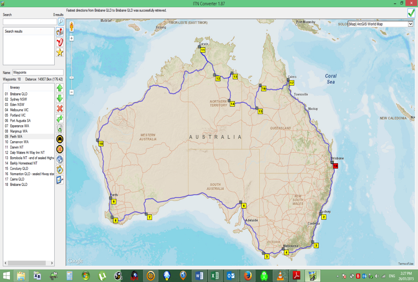
In September 2013 TJ (Trevor) Evans, completed this ride of over
15000Km as an IBA ride in 9 days. There are two distinctions with this
ride, it was ridden on mainland Australia and a small section of around
710Km of predominately dirt Highway (including numerous river
crossings) between Borroloola in the Northern Territory and Normanton
in Queensland (see notes at end), which was bypassed as per the map
below:
The Ride - Rules
- The
ride
may be started at any location on the National Highway 1, with its
finish location at the start point. The entire route must be completed
using the National Highway 1 by following the appropriate route markers
and map as outlined above. The ride may be run either clockwise or
counter-clockwise (anti-clockwise).
- Two
witnesses are required at the start and finish in line with
requirements of other extreme rides.
- Electronic
printed receipts, along with the Ride Log and any other supplemental
documentation, i.e., satellite marking/tracking, GPS tracks generated
during the ride and in some cases photographs of the rider and
motorcycle, may be used to assist the verification team with your
application.
- Corner
points - the
following corner points are required to be documented as per para 3,
keep in mind that electronic printed receipts are the preferred
documentation:
- Brisbane,
Queensland
- Sydney,
New South Wales
- Eden,
New
South Wales
- Melbourne,
Victoria
- Portland,
Victoria
- Port
Augusta, South Australia
- Esperance,
Western Australia
- Manjimup,
Western Australia
- Perth,
Western Australia
- Carnarvon,
Western Australia
- Darwin,
Northern Territory
- Daly
Waters Hi Way Inn, Northern Territory
- Borroloola,
Northern Territory
- Barkley
Homestead, Northern Territory
- Cloncurry,
Queensland
- Normanton,
Queensland
- Cairns,
Queensland
- Application
for verification, see below.
6. You must have previously been awarded a certificate for completion of a SS1600K or SS2000K, or equivalent ride.
Documentation:
See http://www.ironbutt.com/rules/ss1000.pdf
Fees: $50
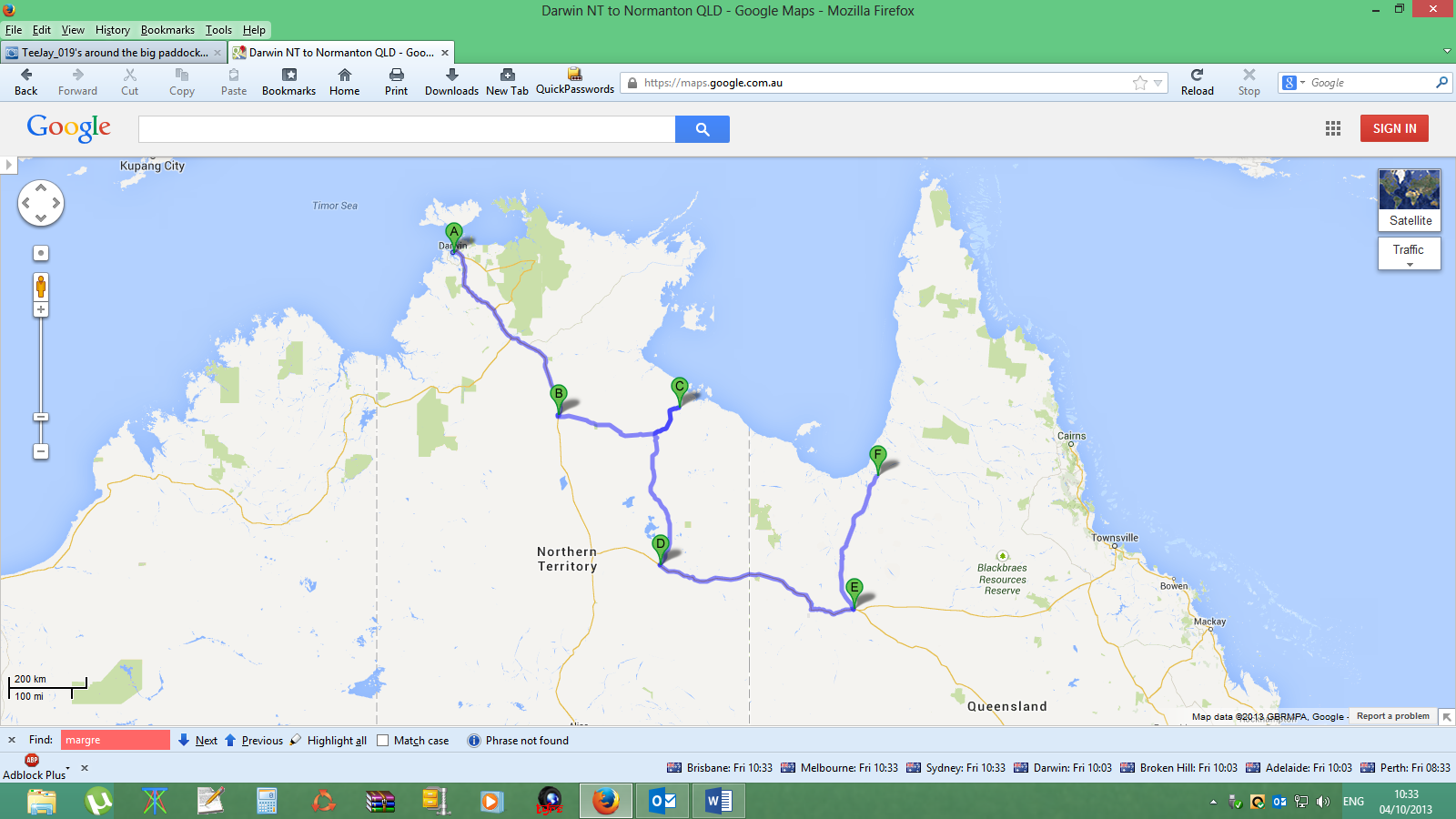
Notes:
Please be aware that, in the Northern Territory, Highway 1 turns east
at Daly Waters Hi Way Inn NT onto the Carpentaria Hwy with the sealed
section finishing at Borroloola NT. *The National Hwy 1 from here
to Normanton QLD is a dirt road (around 710Km) (see * below). To
bypass this section of the National Hwy, at Borroloola, retrace your
route back to McArthur NT (also known as Cape Crawford NT) and head
south on the Tablelands Hwy to Barkley Homestead, head east to
Cloncurry QLD then north on the Bourke Developmental Rd to Normanton
QLD where you will pick up the National Hwy 1 again.
 WARNING
Reason for bypass:
 Here is
part of an extract from a
4X4 road trip across the Borroloola to Normanton road (part of Highway
1) - “The
Calvert River crossing (between Borroloola and Hells Gate Roadhouse)
can only be done in a high-clearance 4X4 fitted with a snorkel. Carry
spare fuel, tyres, drinking water, fan belt, radiator hoses, fuel
filter, etc. Recovery gear is mandatory in these remote areas”.
(In a dry season with low water this crossing could be done, possibly
with assistance and a high clearance off road motorcycle (and may have
already been done); riders should be aware that crocodiles, both
salties and freshies have been sighted at this crossing and a number of
other river/creek crossings).
Here is
part of an extract from a
4X4 road trip across the Borroloola to Normanton road (part of Highway
1) - “The
Calvert River crossing (between Borroloola and Hells Gate Roadhouse)
can only be done in a high-clearance 4X4 fitted with a snorkel. Carry
spare fuel, tyres, drinking water, fan belt, radiator hoses, fuel
filter, etc. Recovery gear is mandatory in these remote areas”.
(In a dry season with low water this crossing could be done, possibly
with assistance and a high clearance off road motorcycle (and may have
already been done); riders should be aware that crocodiles, both
salties and freshies have been sighted at this crossing and a number of
other river/creek crossings).
*Due to the inherent high risk
of this
segment of road, the IBA
will not verify any rides utilising this section. This may
change in the future should the risk of this section of road be
mitigated.